

- Amusement
- Anywhere
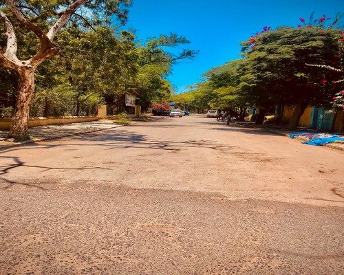
Kezira Area
Where is the Kezira Area?
Kezira (often spelled Kezira or Gezira locally) is a historic neighborhood and commercial district located within Dire Dawa City Administration, in eastern Ethiopia. Dire Dawa lies along the main transport corridor connecting Addis Ababa to Djibouti, making Kezira one of the most strategically placed urban areas in the country.
Kezira sits close to the Dechatu River basin, in the central lowland zone of Dire Dawa, at an average elevation of about 1,200 meters above sea level. Unlike the surrounding highlands of eastern Oromia, the area has a semi-arid climate, characterized by hot temperatures and seasonal rainfall.
Administratively, Kezira is part of Dire Dawa city itself rather than a separate woreda. It is widely regarded as one of the oldest and most influential quarters of the city, playing a key role in Dire Dawa’s political, economic, and cultural life.
How to Get There
Reaching Dire Dawa
Dire Dawa is one of Ethiopia’s most accessible cities:
- By air: Dire Dawa International Airport (DIR) has regular flights from Addis Ababa.
- By road: The Addis Ababa–Dire Dawa highway is fully asphalted, covering roughly 445 km.
- By rail: The Addis Ababa–Djibouti standard gauge railway stops at Dire Dawa, reflecting the city’s historic rail importance.
Getting to Kezira
Once in Dire Dawa, Kezira is easily reachable:
- It lies near the city center, close to major roads and markets.
- Local taxis (blue-and-white minibuses or Bajaj tricycles) serve the area continuously.
- Many parts of Kezira are walkable, especially around market streets and administrative zones.
Because it is an urban district, no special vehicle or guide is required, unlike remote highland destinations.
Things and Places of Interest in Kezira Area
Urban and Commercial Life
Kezira Market Area
Kezira has long been a commercial hub. Local markets and small shops sell:
- Grains, spices, and khat
- Imported goods from Djibouti
- Household items and electronics
The market reflects Dire Dawa’s role as a trading crossroads between the Ethiopian highlands, Somali Region, and Djibouti.
Historic Trading Streets
Several streets in Kezira still follow the layout established during the early 20th century, when Dire Dawa grew around the railway. Walking through these areas gives a sense of how commerce shaped the city.
Cultural and Religious Sites
Mosques and Churches
Kezira reflects Dire Dawa’s religious diversity:
- Historic mosques serving the Muslim-majority population
- Orthodox and Protestant churches within walking distance
Religious life here is active but integrated into everyday urban routines rather than formal tourism.
Everyday Multicultural Life
Kezira is known for its ethnic mix, including Oromo, Somali, Amhara, Harari, Gurage, and others. This diversity is visible in:
- Languages spoken on the street
- Food stalls and coffee houses
- Clothing styles and social customs
The Dechatu River Environment
Although seasonal and prone to flooding, the Dechatu River has historically shaped settlement patterns in Kezira.
- During dry seasons, parts of the riverbed are used as walking routes or informal gathering areas.
- During heavy rains, the river reminds residents of the fragile relationship between the city and its natural environment.
Urban flood-control and river-management efforts are part of Dire Dawa’s modern development challenges.
Culture and Daily Life in Kezira
Kezira is less about monuments and more about lived culture.
Daily scenes include:
- Early-morning market deliveries
- Coffee ceremonies in homes and small cafés
- Street-side food vendors serving sambusa, injera, and roasted grains
- Evening social gatherings along busy streets
The pace of life is fast compared to rural eastern Ethiopia, yet still grounded in long-standing traditions.
History of the Kezira Area
Birth of Dire Dawa and the Railway
Kezira’s importance is inseparable from the Ethio–Djibouti Railway, built in the early 1900s.
- Dire Dawa was founded primarily as a railway city after Harar was bypassed due to its mountainous terrain.
- Kezira developed as one of the earliest residential and administrative quarters serving railway workers, traders, and officials.
This made Kezira one of the first places in eastern Ethiopia to experience urban planning, wage labor, and modern trade networks.
Colonial-Era Urban Influence
While Ethiopia was never formally colonized, Dire Dawa—and Kezira in particular—was heavily influenced by:
- French railway engineers
- Foreign merchants
- Early international commerce
Some older buildings and street layouts still reflect this period, even if many structures have been replaced or modified.
Political and Administrative Role
Over the decades, Kezira has remained close to the administrative heart of Dire Dawa.
- Government offices, courts, and civic institutions developed nearby.
- The area has frequently been a center for political activity, demonstrations, and public gatherings.
This has made Kezira not just a residential zone, but a place where national and regional issues often surface at street level.
Modern Challenges and Transformation
Like much of Dire Dawa, Kezira faces:
- Rapid urban population growth
- Flood risks from seasonal rivers
- Infrastructure strain and informal housing expansion
At the same time, urban renewal projects, road upgrades, and commercial investment continue to reshape the area.
Why Kezira Matters
Kezira is not a classic tourist attraction—and that is exactly its significance.
It represents:
- The historical core of Dire Dawa’s urban identity
- Ethiopia’s connection to Djibouti and global trade
- A living example of multicultural coexistence in eastern Ethiopia
Visiting Kezira is less about sightseeing and more about understanding how a modern Ethiopian city grew, adapted, and continues to evolve at the crossroads of geography, trade, and culture.
Explore

Hotels

Restaurants
Tourist Sites