

- Amusement
- Anywhere
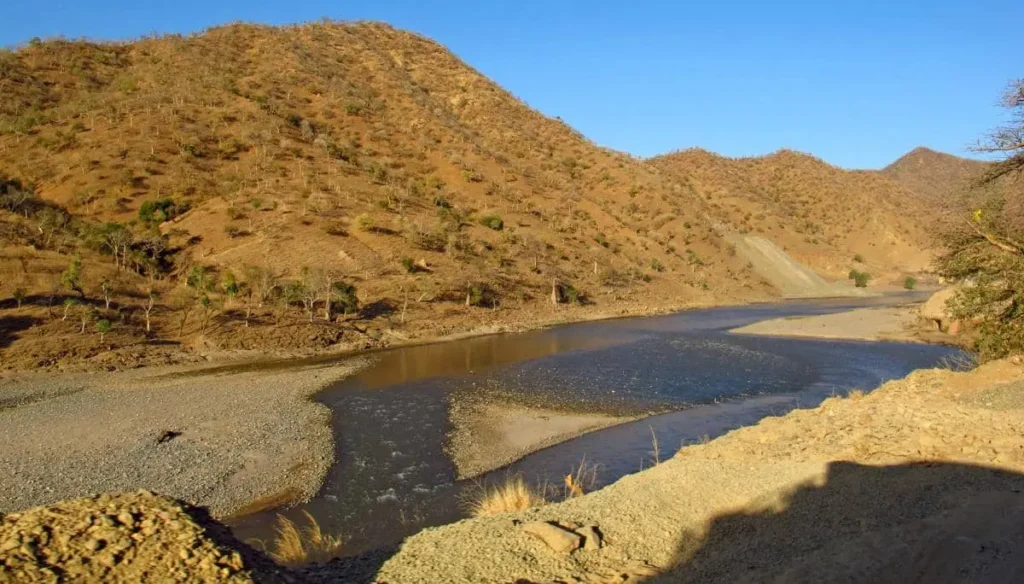
The Dechatu River Walk
Where is the Dechatu River Walk?
The Dechatu River Walk follows sections of the Dechatu River, which runs through Dire Dawa City Administration in eastern Ethiopia.
The Dechatu River originates in the eastern Ethiopian highlands, mainly from the Ahmar Mountains and surrounding escarpments, and flows down into Dire Dawa before continuing eastward to join the Goro River, a tributary of the Wabi Shebelle river system.
Within Dire Dawa, the river cuts directly through the urban fabric, dividing parts of the old city and newer neighborhoods.
-
Location: Dire Dawa City Administration
-
Elevation of city: ~1,200 m above sea level
-
River type: Seasonal (ephemeral), with flash flooding during heavy rains
-
Climate zone: Semi-arid lowland
The “river walk” is not a single formal trail, but rather a series of walkable stretches along embankments, bridges, and informal paths used daily by residents.
How to Get There
Reaching Dire Dawa
-
By road: Addis Ababa – Harar – Dire Dawa highway
-
By air: Dire Dawa International Airport with regular domestic flights
-
By rail: Modern Addis–Djibouti railway (station outside the historic core)
Accessing the Dechatu River Walk
-
The river is easily reached from multiple parts of the city:
-
Near the old railway area
-
Close to central markets
-
Around several major bridges crossing the river
-
-
Short walks or taxi rides from anywhere in central Dire Dawa
No permits or guides are required, but local awareness matters:
-
Avoid walking in or near the riverbed during the rainy season
-
Ask locals about recent rainfall upstream before visiting
Things or Places of Interest Along the Dechatu River Walk
Urban River Landscape
-
Wide, stony riverbed that remains dry for much of the year
-
Steep embankments shaped by flash floods
-
Views of:
-
Old neighborhoods
-
Bridges linking historic and modern Dire Dawa
-
Daily city life unfolding along the river’s edge
-
Unlike manicured riverfronts, the Dechatu feels raw and functional, revealing how cities adapt to nature rather than control it.
Bridges and Crossing Points
-
Multiple road and pedestrian bridges cross the Dechatu River
-
These bridges are:
-
Key social meeting points
-
Popular observation spots during rainy-season floods
-
-
From these crossings, you can see how quickly the river can transform from dry gravel to roaring water.
Daily Life Along the River
Walking along the Dechatu River means observing:
-
Children playing on dry riverbanks
-
People crossing on foot when water levels are low
-
Informal washing, resting, and social gatherings
-
Livestock occasionally moving through the riverbed
This is not staged tourism — it’s ordinary urban survival and routine.
Culture and City Life Around the Dechatu
A Shared Urban Space
The Dechatu River is one of the few shared open spaces in Dire Dawa.
Communities living along the river include:
-
Oromo
-
Somali
-
Amhara
-
Harari
The river does not belong to one group or neighborhood — it belongs to the city as a whole.
Markets, Movement, and Memory
-
Informal markets often develop near river crossings
-
Foot traffic increases where bridges connect major roads
-
Older residents associate the river with:
-
Childhood memories
-
Past floods
-
Lost homes and rebuilding efforts
-
Listening to people talk about the Dechatu reveals emotional layers that no signboard could explain.
Environmental Reality of the Dechatu River
Seasonal Flooding
The Dechatu is infamous for sudden flash floods.
-
Heavy rainfall in the surrounding highlands can cause floods even when the city itself is dry
-
Floodwaters move extremely fast through the narrow channel
-
The river has caused:
-
Loss of life
-
Destruction of homes
-
Repeated displacement of families
-
Any river walk must be approached with respect, not casual leisure assumptions.
Flood-Control Infrastructure
In recent years, authorities have worked on:
-
Reinforced embankments
-
Channel widening
-
Flood management projects
These efforts aim to balance safety, urban development, and environmental flow, though challenges remain.
History of the Dechatu River in Dire Dawa
A River Older Than the City
The Dechatu River shaped the land long before Dire Dawa existed.
When the railway reached Dire Dawa in 1902, the city was built around — not away from — the river, making flooding an immediate concern.
Floods and Collective Memory
Major floods, especially in the 20th century, deeply affected Dire Dawa:
-
Entire neighborhoods were swept away
-
Infrastructure was repeatedly rebuilt
-
Floods became reference points in local storytelling (“before the flood,” “after the flood”)
The river is remembered not just geographically, but historically and emotionally.
Modern Urban Challenges
As Dire Dawa expanded:
-
Informal settlements grew close to the river
-
Environmental pressure increased
-
Flood risks intensified
The Dechatu now represents the tension between:
-
Urban growth
-
Environmental limits
-
Social vulnerability
Why Walk Along the Dechatu River?
You don’t walk the Dechatu River to relax in the traditional sense.
You walk it to:
-
Understand Dire Dawa beyond landmarks
-
See how people coexist with risk
-
Observe a city shaped by water, not decoration
-
Experience an urban space that is honest, imperfect, and alive
If mountains like Gorro Gutu tell the story of nature and rural life,
the Dechatu River Walk tells the story of urban Ethiopia — resilient, complex, and unfinished.
Explore

Hotels

Restaurants
Tourist Sites